Unraveling the Causes of High Earthquake Activity in the Philippines and Indonesia
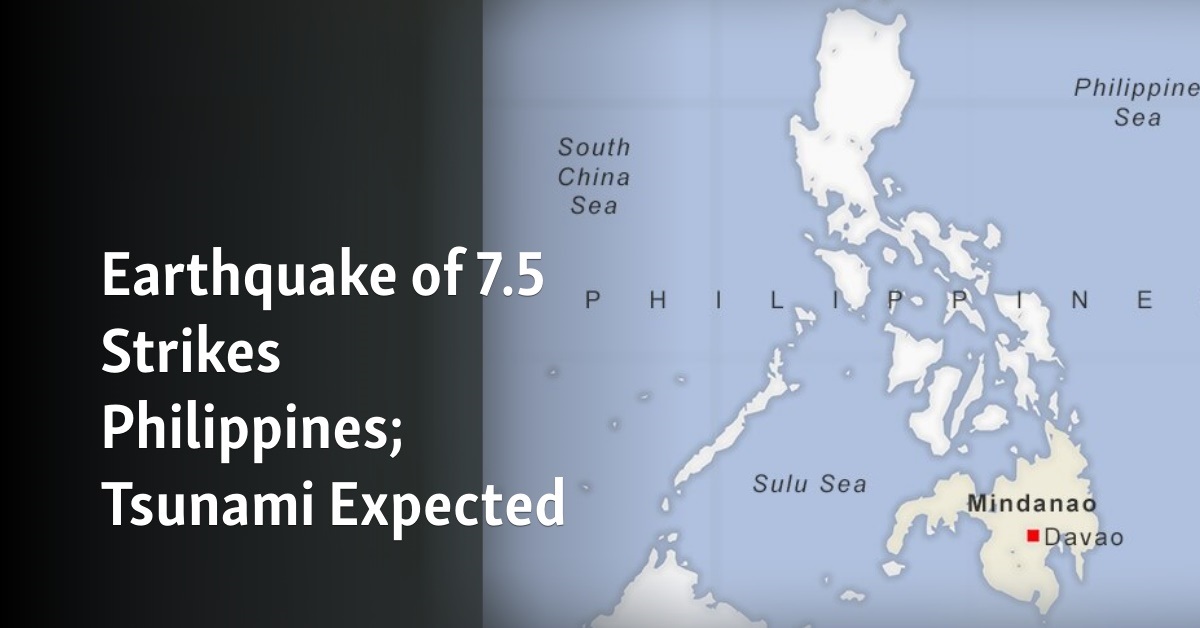
Image REUTERS
The Philippines and Indonesia, located on the Pacific Ring of Fire, are no strangers to seismic activity. Earthquakes are a frequent and often devastating natural occurrence in these countries. Recently, a powerful earthquake that shook the southern Philippines resulted in at least one fatality and several injuries, as terrified residents fled their homes and sought higher ground following a tsunami warning. The primary cause of the high frequency and intensity of earthquakes in the Philippines and Indonesia is their geographical position on the Pacific Ring of Fire, where around 90% of the world’s earthquakes occur. This major area in the basin of the Pacific Ocean is aptly named for its intense seismic and volcanic activity, which is due to the constant interaction of the earth’s tectonic plates. In particular, the Philippine and Indonesian archipelagos are located in complex subduction zones. A subduction zone is a region where one tectonic plate slides beneath another, sinking into the earth’s mantle. This process triggers powerful earthquakes and volcanic eruptions. The Philippines, for instance, is sandwiched between the Philippine Sea Plate and the Eurasian Plate, while Indonesia is at the juncture of the Indo-Australian Plate, the Pacific Plate, and the Eurasian Plate. The continuous movement and collision of these plates produce significant seismic activity. Megathrust earthquakes, the planet’s most powerful seismic events, occur at subduction zones. The sudden slip along the fault between the plates releases a tremendous amount of energy, causing an earthquake. When the slip happens at the seafloor, it displaces a massive volume of water, leading to tsunamis, which can be equally, if not more, destructive than the earthquake itself. The devastating 2004 Indian Ocean earthquake and tsunami, which severely affected Indonesia, is an infamous example of a megathrust earthquake.

The unique geography of the Philippines and Indonesia, comprised of many islands, means that large populations live near the sea. High seismic activity in these regions not only triggers earthquakes but also increases the risk of tsunamis. The land and sea interaction in such settings provides a pathway for seismic energy to transfer to the ocean, creating potentially destructive tsunamis. While the primary drivers of earthquakes are natural processes, human activities can also influence seismic activity. Activities such as large-scale mining, dam-induced sedimentation, and the extraction of geothermal energy or groundwater can induce seismic events. Although these human-induced earthquakes are typically of lower magnitude than natural ones, they can still cause significant damage, particularly in regions already prone to seismic activity like the Philippines and Indonesia. The high earthquake activity in the Philippines and Indonesia is primarily due to their location along complex subduction zones within the Pacific Ring of Fire. Despite the inherent risks, millions of people continue to live and work in these areas, their lives intertwined with the Earth’s tireless tectonic activity. As we continue to study and understand these seismic processes, it is hoped that we can improve our predictive capabilities, enhancing disaster preparedness and potentially saving countless lives. Another factor contributing to the high earthquake activity in these regions is the concept of seismic gaps and the recurrence of earthquakes along particular fault lines. Seismic gaps are sections of active faults that have not experienced significant earthquakes for an extended period. They are thought to be sites where stress is accumulating over time, eventually leading to a large-scale earthquake when the stress is released. For example, the movement of the Philippine and Eurasian plates along the Philippine Fault, a major seismic gap, contributes to the high seismic activity in the region. Research has indicated that there might be a link between climate and seismic activity. The weight of water stored in an area during heavy rainfall can cause the crust to deform, leading to increased stress along faults. In contrast, during periods of drought, the removal of this weight can trigger earthquakes. Given that the Philippines and Indonesia are subject to intense rainfall during monsoons, such climatic factors could potentially contribute to their seismic activity. In addition to subduction zones, seafloor spreading centers and rift zones also contribute to the seismicity of these regions. These are areas where tectonic plates are moving apart, and new crust is being formed by magma rising from the mantle. The process of seafloor spreading and rifting is also associated with earthquakes and volcanic activity. The Philippines and Indonesia have some of the world’s most active volcanoes, directly linked to the region’s high seismic activity. Volcanic eruptions themselves can trigger earthquakes, and likewise, earthquakes can trigger volcanic eruptions. For instance, the violent eruption of Mount Pinatubo in the Philippines in 1991 was preceded by a series of earthquakes. Understanding the causes of high earthquake activity in the Philippines and Indonesia is crucial for implementing effective disaster risk reduction strategies. These could include the construction of earthquake-resistant buildings, the development of early warning systems, and public education about earthquake safety. International cooperation and research are also vital to enhancing our understanding of seismic processes, improving our ability to predict earthquakes, and developing effective strategies to mitigate their devastating impacts.
By Roxana Stanica